- text preluat de pe pagina Romaniantourism (http://rtcom.open4web.ro)
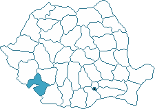
• geographical situation: in the south-western part
of Romania, where the Danube comes out from the narrow path, on the interior
section;
• neighbours: south-east-Dolj; north, north-east-Gorj; west-Caras
Severin; south-the Danube, Yugoslavia, Bulgaria;
• surface: 4,933 square km (respectively 2,1 % of the country's
territory);
• population: 327,000 inhabitants;
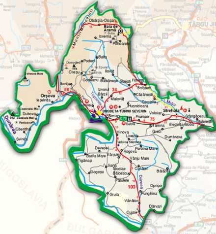
• towns: DROBETA TURNU SEVERIN-capital (with 118,000 inhabitants, on
the left bank of the Danube, on the Portile de Fier I dam lake); Baia de
Arama; Orsova; Strehaia; Vanju Mare.
• relief: it has the shape of an amphitheatre organised in three
different levels descending from north north-west to south-south-east.
Therefore, the level of the mountains from west and north-west accompanies
the Cerna and the left bank of the Danube-Mehedinti Mountains (with Stan
Peak-1,466 m, with karst phenomena), and south-east-Almaj Mountains (gentle
ridges covered with forests). Here it is the Danube narrow path from Cazane,
with heights that hardly surpass 50 m altitude. Then comes the middle level,
the Mehedinti Plateau in north-western part, the Getic Plateau (a depression
corridor, Motru Hills and the high Balacita Plain witch has between 700-200
m). In the south-eastern part it is the lowest level, Oltenia Plain (Blahnita
Plain-with the terraces of the Danube and the wide valleys of Drincea and
Blahnita, with altitudes between 200-40 m) and the Danube Meadow;
• climate: temperate continental, milder than in other parts of the
country, with sub-Mediterranean influences, moist and mild winters and rainy
autumns, north-western winds;
• watercourses: dominated by the Danube and its tributaries: Cerna,
Topolnita, Blahnita, Drancea. The eastern extremity is drained by Motru
(with its tributaries: Coşuştea, Husnita), a tributary of the Jiu.
• Topolnita Cave-(l31 km North from Drobeta Turnu Severin, near Ciresu
village), one of the greatest Romanian caves (over 11 km explored). The
galleries are structured on several levels. Where they cross, there are huge
halls. It has numerous karst spectacular lakes and structures that make it
more beautiful. Speleological preserve, it has been declared monument of
nature;
• Epuran's Cave-(near Jupanesti village in the Mehedinti Plateau, north
of Topolnita), with many halls having impressive dimensions and wearing
suggestive names: “Bears Hall“, “Treasure Gallery“, "Grave Hall", "Basin
Gallery" (with the remarkable "Water fairy scene");
• Gura Ponicovei Cave-(in the area of lake Portile de Fier I and of the
narrow path of the Cazanele Mari), numerous wide multi-level galleries, it
contains huge fallen blocks, remains of the cave bear; speleological
preserve;
• Bulba-(4 km south-west of Baia de Arama), formed by a network of
galleries on 3 levels, difficult to reach.
• The Narrow Path of the Danube-Clisura Cazanelor-presents a succession
of widening and obstructions (“clisuri“) determined by the variation of the
rocks. From the whole narrow path, the Cazanelor area is the most
spectacular. Downstream of the Dubova basin, stretching over 3,6 km, there
are the Cazanele Mici (150-350 m altitude), and upstream the Cazanele Mari
(3,8 km length and 200-350 m altitude). The limestone from the Cazane of the
Danube area favoured the development of the karst structures: steep slopes,
dolinas, numerous caves (Ponicove, Veterani, and Fluturilor).
There is present the sculpture in big rock of DECEBAL
face, leader of Dac people - old origins of Romanian people.
• Portile de Fier I-built together with our Yugoslavian neighbours
behind a concrete dam of maximum 60 m height, it also reaches the county of
Caras-Severin and even further, the Yugoslavian territory;
• Portile de Fier II-Dam Lake located in the area of Gogosul village,
and it is built also together with the ex-Yugoslavia. The lakes do not have
only economic value, but they also are points of tourist attraction due to
the beauty of the surrounding landscape.
• The Natural Bridge from Ponoare (5 km south-west of Baia de Arama),
karst structure, unique in Romania, represented by a huge vault. This unique
landscape was formed by the collapse of a huge cave. Together with the
surrounding karst complex (caves, valleys), it forms an interesting
geological preserve;
• The Lilac Forest-Ponoare (4 km south-west of Baia de Arama),
botanical preserve, unique in Romania (due to the moist and mild climate);
annual folk festivities;
• Starmina Forest-Hinova, formed by willow plantations on sandy soils;
• Izbucul Izverna.
• Traian's Bridge-Drobeta Turnu Severin, built across the Danube, at
the order of Emperor Traian, by the famous architect of the ancient world,
Apollodorus of Damascus. It is a huge bridge, which facilitated the Roman
march into Dacia. Today only the pillar on the Danube bank is preserved;
• Ruins of the Roman Fortress from Drobeta-Drobeta Turnu Severin, near
Trajan's bridge, great fortress securing the Roman domination and control of
the Danube. It dates from the 2nd-5th century, times of Emperors Traian,
Constantine and Justinian. There can be observed traces of the rooms,
altars, baths, warehouses;
• Ruins of the Severin Fortress-Drobeta Turnu Severin, mighty medieval
fortress, famous in the 13th-14th centuries;
• Justinian's Tower ("Theodora's Tower")-Drobeta Turnu Severin (6th
century), ruins;
• Ruins of the Roman Fortress of Dierna-Orsova.
• Gura Motrului Monastery-Butoiesti village, monument of old
architecture built between 1512-1521 by Harvat, chancellor of Neagoe Basarab.
The present church was built in 1653, in a Moldavian style by magistrate
Preda Brancoveanu. Nowadays, the monastery hosts a museum of religious
objects;
• Strehaia Monastery-valuable historical monument built by Matei
Basarab in 1645. Constantine Brancoveanu rebuilt the church in 1690; wall
paintings dating from the 18th-19th century. It was one of the strategic
points of the rebellion of 1821;
• Vodita Monastery-Drobeta Turnu Severin, Varciorova district, it is
one of the oldest monuments of the Romanian feudal art. Built by monk
Nicodim (1364-1370) and Vladislav I, ruler of Wallachia, financed it. In the
18th century, it fell in ruins. The reconstruction following the original
design has begun in 1990.
•
Sf. Ana Monastery located in highest point of Orsova with great view of the
Danube
•
Tismana Monastery, St. Maria - patron of church (extraordinary place and
manners).
• Museum of the "Portile de Fier" Region-Drobeta Turnu Severin, with
departments of history (over 50,000 items presenting the rich past of the
region), ethnography, fine arts, natural science (it also includes an
interesting aquarium);
• Stronghold of Tudor Vladimirescu-Cerneti, the memorial museum
dedicated to Tudor Vladimirescu, the leader of the revolution from 1821.
This house hosted the ammunition used during the revolution.
• Trajan's Monument-Drobeta Turnu Severin, in memory of he who took the
Roman civilisation north of the Danube; realised by sculptor D.Franassovici
in 1906;
• Statue of Decebalus-Drobeta Turnu Severin, in memory of the brave
Dacian who preferred rather to kill himself than surrender to the Roman
conquerors;
• Statue of Apollodorus of Damascus-Drobeta Turnu Severin, in memory of
the famous architect who lived between 60 A.D. and 125 A.D. and who created
one of the greatest constructions of the ancient world.
VINES TRADITIONAL PLACES
Dealul Mare, Corcova.
p.s. "Medinti" in Arabic means "my city".